Thursday, June 12, 2008

4CT Tour - Day Seven - Thursday, June 12th. 08

Tour Day: Seven
Day/Date: Thursday, June 12th, 2008
Time Started: 5:00 AM PDST
Time Ended: 3:15 PM PCDST
Starting Location: Monteray, CA
Ending Location: Ashland, Oregon
Total Miles Today: 517 (25% Two Lane)
Cumulative Miles: 5380
Low Temp: 41F - Pescadero Beach, CA
High Temp: 85F - Redding, CA
Highest Gas Price: $4.67 Pacifica, CA
Lowest Gas Price: $4.61 Redding, CA
States: OR (12)

In case it has not become apparent, I really like to ride early in the day. Perferably early enough to see the sun rise. I left Monteray at 5:00 am and watched the sun come up over the hills and begin to shine on the Pacific. A beautiful sight by any measure.

The temperture as I left Monteray was 46F but quickly dropped to 41F by the time I reached Pescadero Beach. Yep, you guessed it! I stopped and donned my trusty Gerbings liner, complete with a little power. "Problem Solved!"

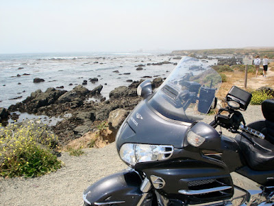
Following the Cabrillo Highway, it did not take long to discover Pidgeon Point Lighthouse gleaming in the early dawn.

You guys will have to bear with me while I show my feminine side. Only in California do you see this kind of flowers at every turn! Just Beautiful!

Once again, either by tremendous planning, (yeah right! LOL) or shear dumb luck, (most likely) I hit it just right with the San Francisco traffic. I came in following the coast on the Cabrillo Hwy and easily entered The Presidio section of San Francisco. In no time at all I was crossing the Golden Gate Bridge and heading away from the in-coming morning traffic.

There is nothing I can add to the Golden Gate photo's. They speak for themselves!


About 85 miles south of Redding, CA I got a call over my bluetooth from yet another Motorcycle Touring Member. I am ashamed to say I do not even know his real name. His MTF handle is FXDB. He was not going to be able to meet me but he did have a suggestion for lunch, just up I-5 at The Old Town Eatery in Cottonwood, CA. Never one to pass up a good meal, I took his advice and pulled in. The people there were great and the food delicious! What more can you ask? Thanks for the suggestion FXDB!

It seemed like I spent the last half of the morning and half the afternoon driving around the magnificent Mt Shasta.

It is almost impossible to take a bad picture of this mountain!

I called it a day once I crossed the Oregon border and found a motel in Ashland. Tomorrow I look forward to riding a side trip to The Colombia River Gorge!

For Bill H. - The Wing continues to perform flawlessly! I never cease to be amazed at their performance level.

To view my entire trip map page "Click Here"

To view the 24 hour SPOT map "Click Here"


"It is not length of life, but depth of life." ~Ralph Waldo Emerson~

Wednesday, June 11, 2008

4CT Tour - Day Six - Wednesday, June 11th. 08

Tour Day: Six
Day/Date: Wednesday, June 11th, 2008
Time Started: 5:00 AM PDST
Time Ended: 5:15 PM PCDST
Starting Location: San Bernadino, CA
Ending Location: Monteray, CA
Total Miles Today: 484 (85% Two Lane)
Cumulative Miles: 4863
Low Temp: 52F - High Desert, CA
High Temp: 85F - Paso Robles, CA
Highest Gas Price: $4.56 Cambria, CA
Lowest Gas Price: $4.49 Mojave, CA
States: CA (11)

First, let me say: TODAY WAS A "GREAT" RIDING DAY!

I left San Bernadino with another early start and rode over the mountains to the Mojave Desert. I was not aware this desert is at such high elevation. (4,200 ft.) The temp dropped dramatically and forced me to find a liner for my mesh jacket. The high desert was also a chore to ride in 40 mph gusts of wind.

One Hundred Sixty Nine miles later I met Ron Willey in Bakersfield, CA. Ron is a great guy and yet another example of the fine people who make up the Motorcyce Touring Forum.

Ron took me on the guided tour of Bakersfield which included Buck Owen's Place, The Buck Owen Blvd and The Merle Haggard DR. We had breakfast together and shot the bull a bit before I took off for the coast.


I took Ron's advice and followed Hwy 58 over to the coast. Trust me when I tell you Hwy 58 has some great twisties in it. I can not remember the last time I drug the right front section of my belly pan, and my right boot toe .... twice! Parts of that road are a blast!

My first view of the Pacific from Hwy 46 looks out over Morro Bay.

I joined Hwy 1 just south of The Hearst Castle at San Simeon.
Some of the many breathtaking views riding Big Sur.

Big Sur never disappoints! Today was no exception, but it was not an easy ride. The road has experienced many rock slides and is really rough in several sections. The south end was bathed in a beautiful blue sky and moderate temps. As I got to the higher elevations I encoutered a fog bank that was moving closer to shore. At one point I was afraid it might cover the entire roadway. As I neared the northern end, the fog pullled back and was replaced by some of the toughest wind gusts I have ever encountered.

The next few pictures are for my wife. On our first trip to California we stopped at the Rocky Point Restaurant on our way south to LA. This restaurant holds special memories for both of us.

The view from Rocky Point.


After leaving Rocky Point I continued to Monteray, where I found a motel for the night. Tomorrow I complete my ride up the coast, riding over The Golden Gate Bridge and returning to I-5 for the trip north.


To view my entire trip map page "Click Here"


To view the 24 hour SPOT map "Click Here"


"Change is upsetting. Repetition is tedious. Three cheers for variation!" ~Mason Cooley~

Tuesday, June 10, 2008

4CT Tour - Day Five - Tuesday, June 10th. 08

Tour Day: Five
Day/Date: Tuesday, June 10th, 2008
Time Started: 3:23 AM PDST
Time Ended: 1:45 PM PCDST
Starting Location: Tuson, AZ
Ending Location: San Bernadino, CA
Total Miles Today: 577
Cumulative Miles: 4379
Low Temp: 65F - Alpine, CA
High Temp: 100F - Imperial Valley, CA
Highest Gas Price: $4.49 San Ysidro, CA
Lowest Gas Price: $3.99 Yuma, AZ
States: CA (11)


Sunrise in the Desert
(Photo taken just east of Yuma, AZ)

I left Tucson, AZ early and continued west, watching a glorious sunrise in the desert! The farther I went the more desolate the desert became. I stopped for breakfast 218 miles later at Yuma, AZ. The temperture was in the low seventies for the majority of the ride to Yuma.

Even in the desert, people plant and take care of flowers.

After I left Yuma the desert took on a much more forboding tone until, at one point, there was little other than sand dunes. I found it interesting how I-10 hugs the Mexican border for a long way. The Border Patrol had set up checkpoints in several locations along I-10 complete with drug sniffing dogs.

It was not long though, before I entered the Imperial Valley, one of the many food basket areas of California. Here crops were plentiful, green and irragated with water from the Colorado River. The elevation is -0, and the temperture quickly sored to 100F just before I headed up the mountians that stand between the valley and the coast. By the time I reached the highest elevation, 4130 ft, the temps had dropped to 65F degrees. This is an area known for high winds but once again, I was fortunate to encounter only moderate winds.

It was another 60 miles to a fog covered San Diego and the temps only rose to 66F. It is hard to believe I could actually be cold thirty minutes after suffereing 100F temps!

Traffic was not light, but nothing to complain about. I quickly made my way south to San Ysidro, where I picked up the required proof to claim the corner. After mailing my letter I decided I needed to make as much mileage northward as possible to avoid the evening rush hour, or if I waited until tomorrow morning, an even worse morning rush hour.

After riding I-15 and 215, I finally called it quits in San Bernadino, CA where I found a Super 8 that fits my needs perfectly. All in all, not a bad day. I did take note of how close yesterdays and todays mileage was.

I have had several comments about how lucky my planning has been. Truth told, I have been planning this trip for nearly two years, in one form or another. I can not take much of the credit because I have had a lot of help routing and planning around the big cities from online forum members who live in those areas. So far all the advice has been spot on! I just hope I am fortunate enough to have this luck continue! (Knock on wood!)

The 2nd "Corner"

The actual southwestern most spot in the US is in a small San Ysidro City Park called Border Field.

Tomorrow I plan to head west, once again, until I reach the Pacific. I plan to take my time and ride up the coast following Big Sur.

I want to thank everyone for the comments and well wishes. I really enjoy reading them at the end of a long day!

To view my entire trip map page "Click Here"

To view the 24 hour SPOT map "Click Here"


Happiness is not a state to arrive at but a manner of traveling. ~Margaret Lee Runbeck~

Monday, June 09, 2008

4CT Tour - Day Four - Monday, June 9th. 08

Tour Day: Four
Day/Date: Monday, June 9th, 2008
Time Started: 3:50 AM CDST ( I rode through two time zones today and gained two hours)
Time Ended: 1:45 PM PCDST
Starting Location: Fort Stockton, TX
Ending Location: Tuscon, AZ
Total Miles Today: 576
Cumulative Miles: 3802
Low Temp: 70F - Fort Stockton, TX
High Temp: 100F - Tuscon, AZ
Highest Gas Price: $3.99 El Paso, TX
Lowest Gas Price: $3.66 Tuscon, AZ
States: NM, AZ (10)

The goal was to meet Jason Foley, a former Unit Mgr with PM, 240 miles away in El Paso, TX for breakfast. I left Fort Stockton at 3:50 am in cool and windy conditions and set a quick pace westward. I didn't see but two lone deer standing well off the interstate, but I did see a skunk and two armadillos. Oddly, the two armadillos were walking, one in front of the other, down the center line of my side of the interstate. I had a fleeting thought they looked like two bowling balls.

It was good to see Jason once again. He is working as a Unit Manager (similar capacity as PM) for T Mobile.

After leaving Jason, I rode westward to Los Cruses, NM where I took a much needed break. You simply can not beat a nice size hotel/motel lobby if you need a "clean" bathroom.

Who knew New Mexico had so many palm trees?

As I crossed the New Mexico desert I found many different places where signs warned of dust storms and possible zero visibility.

Later I crossed into Arizona, and collected another state border sign for my collection.

The Arizona desert quickly heated up to 100F as the day wore on.

I finally gave in to the heat at Tuscon, AZ and found an economical Econolodge with a great air conditioner and Internet service. It should be an easy day's ride to San Ysidro, CA, the 2nd corner tomorrow.

If interested: I have added the pictures to yesterdays post.

To view my entire trip map page "Click Here"

To view the 24 hour SPOT map "Click Here"


"The late great jazz musician Louis Armstrong once said about jazz, “If you don’t feel it, I can’t explain it.” The same holds true for long distance motorcycle riding. At the end of the day, you either get it or don’t. Like jazz."

Sunday, June 08, 2008

4CT Tour - Day Three - Sunday, June 8th. 08

Tour Day: Three
Day/Date: Sunday, June 8th, 2008
Time Started: 4:15 AM CDST
Time Ended: 2:45 PM CDST
Starting Location: Sulphur, LA
Ending Location: Fort Stockton, TX
Total Miles Today: 673
Cumulative Miles: 3226
Low Temp: 82F - Sulphur, LA
High Temp: 95F - Fort Stockton, TX
Highest Gas Price: $3.99 Fort Stockton, TX
Lowest Gas Price: $3.88 Sulphur, LA
States: TX (8)

I left Sulphur, LA with an early start. I happened to notice on the way out of town the elevation was -11 feet. Only 20 miles or so from the Gulf, it kinda makes you wonder what that town would look like if a Hurricane came calling.

It did not take anytime before I crossed the Texas border and continued on to Beaumont, passing through around 4:45 am. Twenty miles into Texas I saw a sign that pronounced El Paso, 837 miles. Man, Texas is really big!

My timing could not have been better for the traffic in Houston and San Antonio. I rode through Houston between 6:30 and 7:00 am. It was on to San Antonio at around 9:30 am. Traffic was next to nothing in both cities.

I will say I have ridden in a lot of big cities and I believe Houston takes a back seat to no one when it comes to mega freeways. I have never seen so many elevated bridges and roads.

Funny Billboard of the day: " If you don't see a Lone Star, you're in a foreign country!" Apparently they mean it, you see Lone Stars on "EVERYTHING!"

I saw many churches in session as I rode through the three major cities. What struck me as odd was all of them were non-denominational. Hmmm ... I wondered if this is a Texas thing or a growing movement?

The weather today was mild most of the morning. It started out before daylight with thin wispy clouds and a sprinkling of stars. It was not long before the dark clouds gathered and threatened rain until well past San Antonio. I may have seen a half dozen drops of rain, if that.

West Texas .... A whole lot of nuttin!

Beyond San Antonio the clouds cleared and the wind increased to 30 mph with gusts to 40. As the clouds cleared the temps began to rise ending at 95 by the time I reached Fort Stockton. The interstate speed limit is 80 mph but that can be tough to maintain in high winds.

Fort Stockton train station and Oil Platform.

All is well and going as planned. At the present rate I expect to be in San Diego late Tuesday afternoon (Day Five) to collect the second corner.

One last thing: While gassing up, west of San Antonio, I had a chance to see an interesting trike/chopper. The Cheetah Chopper, made in Indiana. I think the guy said it had a 383 Chevy small block in it. I am not a trike or chopper fan but I did think it was interesting. Check out the rear tires!


To view my entire trip map page "Click Here"

To view the 24 hour SPOT map "Click Here"


How do you eat an elephant?

One bite at a time!

Saturday, June 07, 2008

4CT Tour - Day Two- Saturday, June 7th. 08

Tour Day: Two
Day/Date: Saturday, June 7th, 2008
Time Started: 4:30 AM EDST
Time Ended: 2:30 PM CDST
Starting Location: Madison, FL
Ending Location: Sulphur, LA
Total Miles Today: 686
Cumulative Miles: 2553
Low Temp: 72F - Madison, FL
High Temp: 95F - Sulphur, LA
Highest Gas Price: $3.99 Baton Rouge, LA
Lowest Gas Price: $3.89 Loxley, AL
States: AL, MS, LA (7)

I decided to leave early (4:30 am eastern) to get a head start on the heat I knew would be coming later in the day. After riding a bit over a hundred miles, at daybreak, I stopped for a hot breakfast at a Waffle House near the Fl/Al border.

From there it was nothing but interstate, through Alabama, Mississippi and on into New Orleans. I wanted to see the traditional view of downtown New Orleans so I stayed on I-10 rather than take I-12. That proved to be a mistake as Ten was shut down to one lane for several miles right through the heart of town.

I did eventually clear the construction and continued on to Baton Rouge where I had lunch. After riding 686 miles, I called it a day as the thermometer hit 95 degrees just west of Lake Charles in a small burg called Sulphur, LA. Tonight I have really good Internet access and I have added the pictures to the previous posts.

No pictures today. Not a lot to photograph while at interstate speeds.


To view my entire trip map page "Click Here"

To view the 24 hour SPOT map "Click Here"


"If you're not learning, you're dying. If you're not laughing, you might already be dead" ~Oliver Leveritt~

Friday, June 06, 2008

4CT Tour - Day One - Friday, June 5th. 08

Tour Day: One
Day/Date: Friday, June 6th, 2008
Time Started: 5:45 AM EDST
Time Ended: 3:30 PM EDST
Ending Location: Madison, FL
Total Miles Today: 601
Cumulative Miles: 1867
Low Temp: 82F - Key West, FL
High Temp: 100F - Lakeland, FL
Highest Gas Price: $4.29 Key West, FL
Lowest Gas Price: $3.72 Port St. Lucie, FL
States: FL (4)

The day started with a quick trip to the gas station and the Post Office to officially start the tour. My timing could not have been any better as the sun was just starting to show as I left Key West. For the next hundred miles I was treated to one picture perfect view after another.

I did find a couple of tropical showers along the way that served only to cool things off a bit.

I listened to my common sense and heeded the advice of my Floridian friends and stayed on The Florida Turnpike as I rode north. I could not justify the chance I might get snarled up in a traffic jam on I-75 due to the bridge accident. Normally I have an aversion to riding the same road both ways.

Traffic in the Fort Lauderdale/Miami area was tough to put it mildly. In one section the traffic was at a walking pace for nearly ten miles. When I finally got up to the blockage it was simply four state troopers sitting on the side of the highway with their lights on. No other visible problem. I am always amazed how how little it takes to snarl traffic in large cities.

The heat today was a real test. By late morning it was in the high nineties and reached 100 f by the time I made it back to Wildwood at I 75. I was determined to get my 600 miles in so I pushed on.

I learned another valuable lesson today ... In Florida, if you do not want it burned.. don't leave it exposed. I have a red circle around my wrists where I let my gloves slip down. All the Gear All the Time was tested to the max today. I stayed in my coat and pants no matter how hot it got.

Again I am in a Holiday Inn with the wrong kind of wireless. Wrong for my laptop at least. That means, again, I am on the lobby computer and I will not be able to load any pictures. Pictures were few and far between today once I left the Keys.

Tomorrow I am going to get a bit earlier start to avoid some of the heat. Other than that, all is well and going as planned.


To view my entire trip map page "Click Here"

To view the 24 hour SPOT map "Click Here"


"If you are not willing to change it, then you must be willing to endure it. "