Wednesday, June 18, 2008

4CT Tour - Day Thirteen - Wednesday, June 18th. 08

Tour Day: Thirteen
Day/Date: Wednesday, June 18th, 2008
Time Started: 5:00 AM CDST
Time Ended: 5:55 PM EDST
Starting Location: Fargo, ND
Ending Location: Marquette, MI
Total Miles Today: 556 (95% Two Lane)
Cumulative Miles: 8728
Low Temp: 48F - Fargo, NC
High Temp: 77F - Duluth, MN
Highest Gas Price: $4.19 - Ironwood, MI
Lowest Gas Price: $4.06 - Superior, WS
States: MN, WS, MI (21)

After studying my maps last night, I made the "executive" decision to leave the interstates and ride two lane state roads.

Following Hwy 10 out of Fargo, and later Hwy 210, I crossed through Detroit Lakes and Brainard, before arriving in Duluth, MN.


No self-respecting motorcycle rider could ever ride through Duluth without paying a visit to The Duluth Trading Company, Riders Warehouse. Better known as the makers of the Stitch! (Aerostitch) No, I did not order a custom fit "stitch" but I did buy the T shirt. :^)

I had always heard their store was nothing but an old warehouse. It's true.

I soon crossed over into Superior, Wisconsin, following Hwy 2, skirting around the shores of Lake Superior, across the narrowest part of the state. It was not long before I had entered Michigan at Ironwood.
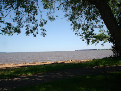
Lake Superior

I had been warned by Bill H that the Upper Peninsula of Michigan could get a bit sparse for services. Bill did not exaggerate! The UP is great if you like riding between the trees and not much else.


Tonight I am in Marquette, Michigan. I am about 165 miles from the Canadian crossing and about two days out from Maine. All continues to go well. Note, I lost another hour today as I entered the Eastern time zone. I think I will be kinder to myself tomorrow and get a slightly later start.

To view my entire trip map page "Click Here"

To view the 24 hour SPOT map "Click Here"

Life is for the living. Never waste a minute of it on regret. ~Patrick Boyle~

Tuesday, June 17, 2008

4CT Tour - Day Twelve - Tuesday, June 17th. 08

Tour Day: Twelve
Day/Date: Tuesday, June 17th, 2008
Time Started: 5:00 AM MDST
Time Ended: 3:55 PM CDST
Starting Location: Gillette, WY
Ending Location: Fargo, ND
Total Miles Today: 641 (30% Two Lane)
Cumulative Miles: 8172
Low Temp: 46F - Gillette, WY
High Temp: 79F - Fargo, ND
Highest Gas Price: $3.99 Spearfish, SD
Lowest Gas Price: $3.99 Bismark, ND
States: SD, ND (18)

Today started, as all other days have, bright and early.

I would not mind waking up to find one of these working for me in my backyard!

Sunrise comes quick in a land with few trees.

About a hundred miles after I started I crossed into South Dakota. I stopped for a breakfast at Spearfish, South Dakota.

At Spearfish I left I-90 and took Hwy 85 north across the endless sea of grass.

Grass as far as the eye can see in any direction!

Somewhere on Hwy 85, in the middle of no where, I crossed into North Dakota.

All day I watched Prong Horn antelopes and deer, seemingly curious about my passing. This Pronghorn buck seemes to be pretty good size.

Today was mostly about mileage. I stopped tonight in Fargo, ND. It should be noted I lost an hour when I crossed back into the Central Daylight Time Zone.

All in all, a very good day.

Tomorrow I cross Minnesota and Wisconsin.


To view my entire trip map page "Click Here"

To view the 24 hour SPOT map "Click Here"


~The biggest risk in life is not living it. ~

Monday, June 16, 2008

4CT Tour - Day Eleven - Monday, June 16th. 08

Tour Day: Eleven
Day/Date: Monday, June 16th, 2008
Time Started: 5:00 AM MDST
Time Ended: 3:35 PM MDST
Starting Location: Big Timber, MT
Ending Location: Gillette, WY
Total Miles Today: 504 (60% Two Lane)
Cumulative Miles: 7531
Low Temp: 36F - Beartooth Pass, WY
High Temp: 76F - Gillette, WY
Highest Gas Price: $4.19
Top of the World Store, Bear Tooth Pass, WY
Lowest Gas Price: $3.99 Gillette, WY
States: WY (16)

It did not take long to ride through Colombia, MT and on to Red Lodge, where I stopped for breakfast at a small cafe. While talking to the locals, I was informed the Beartooth Pass had been closed all weekend due to snow and, as far as they knew, was still closed. I had ridden too far to give up with no more certainty than that. As I left the cafe I met a sheriffs deputy and asked him to confirm or deny the closing. After several radio calls, I knew no more than I did when I started. With that bit of dubious info in hand, I decided to ride until I found something I could not ride over.

Ascending Beartooth from the Montana side is a steep climb indeed! I saw hardly no one else on the road and no other motorcycles on the ascent.

I registered 10,809 ft to the top. I think the official version is 10,847 or something like that.

It was not hard to convince me this road was closed to snow over the weekend. I found drifts on the side of the road as high as 12 ft.

The temperature dropped throughout the climb, finally stabilizing at 36F. Naturally I had my electrics going strong!

I found some sections a bit unnerving. The sun had melted snow and the runoff had refrozen in the shadows. This was my first experience riding over water laced with ice. Fortunately there were only 20 to 30 ft sections like that. Once up there, you really had little choice.


The view was unbelievable!

At one point, coming down the other side of Beartooth, I had the daylights scared out of me when a "HUGE" elk jumped up on the road beside me and began to run right beside the Wing. We exchanged wild eyed stares and I let off the throttle as quickly as I could. He cut across the road directly in front of the Wing and disappeared over the edge.

I stopped to top off my tank and take a break at The Top of the World Store, just after cresting the Beartooth.

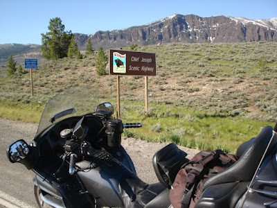
Before long I found Chief Josephs Scenic Highway and began yet another climb.

Beautiful views were everywhere you looked!


Notice the winding road climbing up the side of the mountain.


Silhouettes of indians at the top of Chief Josephs Highway.


There simply are no words to describe the views I saw today. It is an awesome ride, whether you are in a car or riding a bike. Not to be missed!

After decending Chief Josephs Hwy, I eventually rode Hwy 14 across Big Horn National Park. Entering the park from the north involves another steep climb of over 9,000 ft. Once again the temperture dropped down to the low forties and I was forced to rethink my clothing. The views in this park are beautiful as well.

After decending out of the park I eventually found my way back to I-90 and rode the interstate to Gillette, WY, where I am spending the night. The mileage today was not tremendous but the mountains I rode were worth the investment. I am tired but very happy with my day.

Tomorrow I ride the interstates with a goal of higher mileage.

To view my entire trip map page "Click Here"

To view the 24 hour SPOT map "Click Here"


Have a dream, live it. Set a goal, achieve it. ~Unknown~

Sunday, June 15, 2008

4CT Tour - Day Ten - Sunday, June 15th. 08

Tour Day: Ten
Day/Date: Sunday, June 15th, 2008
Time Started: 5:00 AM PDST
Time Ended: 3:35 PM MDST
Starting Location: Spokane, WA
Ending Location: Big Timber, Montana
Total Miles Today: 518 (5% Two Lane)
Cumulative Miles: 7027
Low Temp: 46F - Coeur d' Alene , ID
High Temp: 76F - Big Timber, MT
Highest Gas Price: $4.17 Three Forks, MT
Lowest Gas Price: $3.99 Big Timber, MT
States: ID, MT (15)

My good timing continues today as I rode through Spokane, WA on a Sunday morning at 5:15 am. Not a soul out!

Soon after leaving Spokane I crossed into Idaho.

The sun was directly in my eyes as it rose in the east, a problem I have not had to contend with until today. I decided to stop for breakfast in Coeur d' Alene, ID and let it rise just a bit.

Soon after, I found Lake Coeur d' Alene and did a short ride around one side of it.

There are not a lot of pictures because today was a interstate mileage day. I rode through Idaho's Bitterroot Range and on to the beautiful mountains of Montana.


Tonight I am in Big Timber, MT near my turn off tomorrow to ride The Beartooth Pass and Chief Josephs Highway. I made the decision to stop a bit early today, rather than tackle the next two lane mountain roads after riding over 500 miles the same day.

It should be noted I lost an hour today as I rode east.

All continues to go well.


To view my entire trip map page "Click Here"

To view the 24 hour SPOT map "Click Here"


Travel and a change of place imports new vigor to the mind. ~Unknown~

Saturday, June 14, 2008

4CT Tour - Day Nine - Saturday, June 14th. 08

Tour Day: Nine
Day/Date: Saturday, June 14th, 2008
Time Started: 5:00 AM PDST
Time Ended: 4:35 PM PCDST
Starting Location: Lacey, WA
Ending Location: Spokane, WA
Total Miles Today: 568 (70% Two Lane)
Cumulative Miles: 6509
Low Temp: 41F - Tumwater, WA
High Temp: 73F - Spokane, WA
Highest Gas Price: $4.29 Sedro Wooley, WA
Lowest Gas Price: $3.99 Spokane, WA
States: WA (13)

Just before I left this morning I checked the weather radar and found light rain along the coast of Washington and temps in the low 40's. That was enough to confirm my decision to forgo the Olympic Peninsula and, instead, head for the third corner. I dispensed with the mesh jacket and gloves and went with the textile Killi and warmer gloves.

After a short 130 mile ride I arrived at Blaine,Washington and collected the needed photo's and information to confirm the corner.


It is hard to read but this is the photo in front of the Blaine, WA Post Office.

From there it was on to the fourth and last corner, a "loooonnnnggg way off"! I retraced my route south down I-5 for a short 20 miles before I exited at Sedro Wooley and turned eastward. My route today took me over The Northern Cascades Historic Highway.

If you ever have the opportunity to ride this road, trust me when I tell you, it's "A Must Do"! A big thanks to Mike J for suggesting this side trip.

The well paved road has gentle curves that climb slowly to an altitude of about 5,500 ft or about half as high as the mountains that will surround you.


Throughout the ride you are almost always in sight of a river or a high mountain lake. This is Lake Diablo.

Scenic pull offs make it easy to stop and take in the stunning views.

It has not been long since this road was closed to traffic. Abundant snow still lines the sides of the road.

After coming down from the mountains I crossed a high plains (2500 ft) that appeared to be rich cropland. Apple trees were planted by the thousands. Summer wheat dominated the skyline all the way to Spokane.


Is it just me or can I see the faint outline of the curvature of the earth? While riding that road I thought I could see it.

I rode by two dams today. The first was Chief Josephs Dam.

The second was The Grand Coulee Dam. Both were in the middle of nowhere!

Tonight I am in Spokane, Washington. Tomorrow I cross into Idaho and Montanna. I look forward to my side trip up Chief Josephs Pass.

A couple of housekeeping notes:

This trip has been made bearable in the long hot, dry sections by the use of a 32oz Butler Cup. I was convinced it was butt ugly when I first saw it, but after crossing the desert, it's now my "best friend"! Sipping cold water when you need it the most saves the day!

My other "best friend" has become my LD Riding Shorts. Why? Because they work! I have had no pain in the posterior end after repeated long, hot riding days. If you have ridden a lot in hot, sweaty weather, you will know what I mean.

There! Now I feel better having shared those two tid-bits! LOL


To view my entire trip map page "Click Here"

To view the 24 hour SPOT map "Click Here"


“It is only in adventure that some people succeed in knowing themselves - in finding themselves.” ~Andre Gide~

Friday, June 13, 2008

4CT Tour - Day Eight - Friday, June 13th. 08

Tour Day: Eight
Day/Date: Friday, June 13th, 2008
Time Started: 5:00 AM PDST
Time Ended: 3:00 PM PCDST
Starting Location: Ashland, Oregon
Ending Location: Lacey, WA
Total Miles Today: 561 (20% Two Lane)
Cumulative Miles: 5941
Low Temp: 42F - Grant's Pass, OR
High Temp: 73F - Lacey, WA
Highest Gas Price: $4.39 Ashland, OR
Lowest Gas Price: $4.29 Hood River, OR
States: WA (13)

I left Ashland, OR slightly before daylight, headed north on I-5 with Portland in my sights. I rode through the beautiful wooded mountains of southern and central Oregon. The air was filled with the smell of spruce and pine, while every other truck was forestry related. Oregon is truly a beautiful place to live!

After riding through Eugene and Salem I arrived in Portland. A sprawling metropolis with a scenic downtown. Just north of the downtown area, I turned east with the goal of riding The Historic Columbia River Gorge Highway.

It was not long before I found the highway and began a winding two lane ride along the southern cliffs of the Gorge.
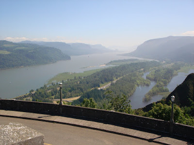
Several times along the way I was treated to panoramic, scenic pull offs with breathtaking views.


Along the way, waterfalls cascade from the cliffs on their way to the Columbia River.


I rode east along the Oregon side of the river to The Hood River Bridge, where I crossed over north to the Washington side.

Once on the Washington side of the river I could look back south, at the majestic MT Hood.


Jaw dropping views were everywhere!


Near Wind River, WA I was lucky enough to sit on a cliff and watch several para-boarders (is that what they are called?) doing their thing. I was amazed at their nerve in such high winds and rough water.

I rode 60 miles on each side of the river, ending the ride back on I-5, where I continued on my way to the third corner of the Tour. Tonight I am in Lacey, WA about 40 or so miles from Tacoma. Tomorrow I will collect the third corner and begin my return trip eastward.
All is going well and the bike continues to perform flawlessly. (Knock on wood!)

Once again, I would like to thank the many people who have e-mailed support and posted comments here on my blog. I really do appreciate all them!

To view my entire trip map page "Click Here"

To view the 24 hour SPOT map "Click Here"


Let me tell you the secret that has led me to my goal: my strength lies solely in my tenacity. ~Louis Pasteur ~