
 The Land Between the Lakes is a National Recreation Area. The National Park stamp can be found at the Golden Pond Visitor Center on The LBL Trace.
 Fort Donelson is strategically located atop a hill overlooking the Tennessee River, near Dover, TN. This fort was the site of a major Civil War battle as Grant moved his Union Army south to Shiloh, Tupelo, Vicksburg and Natchez.
 The Visitor Center at Fort Donelson.
  Cannons positioned north, covering Grant's approach on the Tennessee River.
Carolyn and I departed Paducah Sunday morning, November 11th, around 9 am, heading south to Shiloh National Military Park. This park is the site of a Civil War Battlefield and Cemetery. While there, we toured the grounds and watched the National Park video.
I always come away with a greater understanding of the tremendous costs our civil war inflicted on both our country and it’s people. I never cease to be astonished at the enormous numbers of troops involved in each of the major battles and the astounding death and causalities.

 The Shiloh Visitor Center. This site also has the Tennessee Trail of Tears Stamp.
 The National Park stamp can be found in the Shiloh Book Store.
 The Shiloh National Cemetery entrance.
 The fall colors only added to the beauty of the park.
 Canons overlooking the Tennessee River.
 From Shiloh we rode southeast into northwestern corner of Alabama to Colbert Ferry on The Natchez Trace. This is an Alabama state site with a National Park designation. Unfortunately, the visitor center was closed for some unexplained reason and we were not able to collect this stamp. All was not lost as the beautiful fall colors along the route more than made up for the effort
 .
. 
 From Colbert Ferry we continued southwest, riding the Natchez Trace to Tupelo, MS where we found the visitor center for the Trace, Brice’s Cross Roads and The Tupelo National Battlefield.
We called it a day here and stayed in Tupelo for the evening.
 The next morning we continued our scenic ride down The Natchez Trace, enjoying the fall beauty at every turn. Eventually we arrived at Vicksburg, MS where we toured Vicksburg National Military Park and watched the National Park video. This battlefield site was the next in the series as the Union troops moved south to free the Mississippi River at fortress called Natchez.
 From Vicksburg we crossed the Mississippi River and rode northwest to Poverty Point State Historic Site at Epps, LA. This park was approved for National Park status but, as it turned out, turned down the designation. Therefore, the park stamp will not count for the Ironbutt Tour.
This site preserves the archeological digs of the oldest known people ever found in North America. Poverty Point commemorates a culture that thrived during the first and second millennia B.C. Carolyn and I both found it to be one of the most interesting sites we have visited. Here we watched the video and took a riding tour of the site.
It started to rain as we left Poverty Point and continued raining for the 80-mile ride south where we crossed back into Mississippi at Natchez.

After riding in Mississippi many times, I finally collected a picture of their state sign (in the rain) for my collection. Mississippi seems to have a habit of placing their state signs in dangerous locations.
 Arriving in Natchez late in the afternoon, we quickly rode to The Natchez National Historic Park at Melrose. From the magnificent antebellum estate of John McMurran, to the downtown home of African-American barber and diarist William Johnson, to the French Fort Rosalie, this park is dedicated to the rich history of Natchez, it's people and the key role Natchez played in the Civil War.
 The picture above is the back of the Melrose Mansion seen above.
Leaving Melrose near dark, we called it a day  Tuesday morning we left the Natchez area and rode west across Louisiana to Alexandria, where we turned south to join I-10. After picking up the interstate, we rode west to Beaumont, TX and on northeast for 30 miles to Kountze, TX and The Big Thicket National Game Preserve.
Big Thicket was the first National Game Preserve. Designation of Big Thicket as a national preserve created a different management concept for the National Park Service. Preserve status prevents further timber harvesting but allows oil and gas exploration, hunting, and trapping to continue. In 2001 the American Bird Conservancy designated Big Thicket National Preserve a Globally Important Bird Area. The preserve is composed of 12 units comprising 97,500 acres. It was designated an International Biosphere Reserve by the United Nations in 1981. The protected area will provide a standard for measuring human impact on the environment.
Big Thicket treated us to temps of 85 degrees and overwhelming humidity. It did not take us long to change to our summer riding gear, regardless of the impending pop-up rain showers. We returned to I-10 and rode east to Lake Charles, LA where we spent the night.  Wednesday morning we left Lake Charles and traveled east on I-10. Arriving in New Orleans we rode into the French Quarter and found parking on the street. We removed anything of value on the Wing and covered the bike while we walked to the two National Parks.
The first park was The New Orleans Jazz National Historial Park, obviously celebrating New Orleans contributions to Jazz.
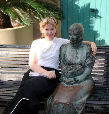 Carolyn, taking a break with a new found friend.....
  Five blocks up Decateur St. we found the second National Park. Jean Lafitte National Historical Park celebrates:
Acadian Cultural Center - Lafayette
Prairie Acadian Cultural Center - Eunice
Wetlands Acadian Cultural Center - Thibodaux
Barataria Preserve - Marrero
Chalmette Battlefield and National Cemetery - Chalmette
French Quarter Visitor Center - New Orleans

 Picturesque Jackson Square
  The historic New Orleans French Quarter.
  Cafe du Monde - Home of lengendary powdered sugar beignets and chicory coffee.
 We left New Orleans mid-day and quickly crossed the Mississippi River, hugging the Gulf Coast on Hwy 90, through Bay St. Louis, Pass Christian, and Biloxi.
We rode through the heart of the Katrina damage, in New Orleans and along the Gulf Coast, still plainly visible two years later. I was very encouraged by the new construction, both private and government. Almost all of the major bridges we crossed were new construction.


 We soon arrived at Gulf Islands National Park at Ocean Springs, MS. This is the first of two Gulf Island Parks. After touring the visitor center and collecting the stamp, we located a motel and restaurant at Pascagoula, MS for the evening.
  The next morning we woke to a steady twenty mph wind with gusts to forty. This presented a big problem riding the coast highway with all the sand. We continued riding east along Hwy 90, following the coast and circling Mobile Bay through Battles Wharf, Faithhope, Foley, and on to Pensacola, FL. Arriving in Pensacola, FL, we crossed the bay bridge to visit Gulf Islands National Seashore.
 After leaving Gulf Breeze, FL we turned north and continued to fight the strong winds, riding I-65 to Montgomery, AL before calling it a day.
Overnight the temps dropped dramatically with morning temps of 29 degrees. We took our time leaving, allowing the temps to rise to 41 by the time we left. Fortunately the strong winds had subsided. It was 427 miles home and the temps were never warmer than a chilly 54 degrees. Quiet cold at Interstate speeds for long periods.
We arrived home at 4:15 pm, after riding a total of 2,218 miles.
"Motorcycling in itself is not inherently dangerous. But to a similar degree to aviation, it is terribly unforgiving of any carelessness,incapacity or neglect." ~Unknown~


 Leaving Cincinnati, I rode northeast 120 miles to
 Finally! Beautiful two-lane roads south from
 The visitor center at


 I continued following two lane mountain roads, crossing I-75, east to

 Andrew Johnson's original home.
 Andrew Johnson is buried in the family cemetery on top of a hill overlooking downtown