Thursday, June 26, 2008

4CT Tour - Thursday, June 26th. 08

Streets & Trips Map


SPOT Satellite Tracking Map of Tour

"The elephant has been eaten!"


I made it home safely this morning around 7:30 am.

It's "GREAT" to be home!

Now for a few stats:

Mileage Chart


I rode 11,897 miles total. For the entire ride I averaged 541 miles per day.

The "official" Four Corners Tour from Key West, FL to San Ysidro, CA to Blaine, WA, to Madawaska, ME totaled 9,045 miles. I rode the tour in 15 1/2 days with an overall average of 565.3 miles per day.

As listed above, 7 days were over 600+ mile days. Ten days were +500 miles, 3 were + 400 and 2 were +200.

The 3-400 mile days were two-lane side trips. (Big Sur / San Francisco - along the California coast, The Colombia River Gorge in Washington, Beartooth Pass , Chief Joseph Highway and Big Horn National Park in Montanna/Wyoming

Other higher mileage two-lane side trips included The Northern Cascades Historic Highway in Washington and a two-lane ride from Fargo, ND to Ottawa, Ontario. I also had the opportunity to ride through Boston, MA, Providence, RI, New York City, NY and Baltimore, MD on the ride home.

The 2-200 plus mile days were the short trip from Valdosta, GA to Orlando, FL (Day Plus One), and from Lexington, KY to Paducah, KY (Day Twenty One), the last day.

I enjoyed two rest days in Maine after completing the tour. With the Wing parked and no mileage, I excluded both days from the mileage totals and averages.

I count myself extremely fortunate not to have had an accident or even a close call during the Tour.

Gas Price - Temp Chart


The highest gas prices I found in the US was $4.67 in Pacifica, CA. (a suburb of San Francisco, CA)

The lowest gas price in the US was $3.66 in Tuson, AZ

The highest gas prices encountered in Canada was 1.41 per liter in Montreal, Quebec and Riviere Du Loup, Ontario.


I did not keep miles per gallon info.

The high temp of 100F came, as expected, in the panhandle of FL and The Imperial Valley, CA.

The low temp of 36F was found 11,000 ft up at the top of Beartooth Pass, Wyoming between the snowbanks.

My SPOT map has now been disabled. Thanks again to the many who followed my adventure and posted comments. All were much appreciated.

This was truly a ride that I will never forget!


"If you're not living on the edge, you're taking up too much space."~Anonymous~

Wednesday, June 25, 2008

4CT Tour - Wednesday, June 25th. 08

Tour Day:
Day/Date: Wednesday, June 25th, 2008
Time Started: 5:08 AM EDST
Time Ended: 3:20 PM EDST
Starting Location: Wilmington, Delaware
Ending Location: Lexington, KY
Total Miles Today: 652
Cumulative Miles: 11,525
Low Temp: 61F - Wilmington, Delaware
High Temp: 91F - Lexington, KY
Highest Gas Price: $4.09 Morgantown, West Virginia
Lowest Gas Price: $3.95 Fredrick, MD
States: Maryland, West Virginia (34)


Today was all about mileage so there were no pictures. I promised myself last night I would take it easier today, maybe sleep in and ride less. After all, in this heat, I did not plan to ride the entire 912 miles in one day. I woke up at 3:30 am, laid there a while, and finally decided to hit the road, promise or no promise.

I quickly jumped back on I-95 south and in no time I was led into the heart of Baltimore. After circling The Chesapeake Bay shores, I passed under The Fort McHenry Tunnel , near Camden Yards baseball stadium. I-95 eventually joined I-270 -70 and I was finally moving west.

A note about EZ Pass. After receiving advice from my northeast friends, I made sure I had an EZ Pass with me for this trip. I must say, it is worth the trouble to get one. The New Jersey Turnpike has "Express Lanes" that allow you to go through the toll booths at 55mph. Talk about a time saver! The EZ Pass worked like a charm from Maine to Maryland on the many toll roads and bridges of the northeast.

After stopping for breakfast in Fredrick, Maryland, I continued to follow I-70 west, eventually joining I-68, The National Freeway.

At Morgantown, West Virginia I joined I-79 for the quick run to Charleston, WV where I joined I-64. In no time at all I crossed the border into good ole KY and rode to Lexington before I finally called it a day.

Tomorrow I will ride the 261 miles home, arriving sometime late morning.


To view my entire trip map page "Click Here"

To view the 24 hour SPOT map "Click Here"


"Only bikers understand why dogs like to stick their heads out of car windows."

Tuesday, June 24, 2008

4CT Tour - Tuesday, June 24th. 08

Tour Day:
Day/Date: Tuesday, June 24th, 2008
Time Started: 4:23 AM EDST
Time Ended: 3:30 PM EDST
Starting Location: Peru, Maine
Ending Location: Wilmington, Delaware
Total Miles Today: 573
Cumulative Miles: 10,883
Low Temp: 56F - Auburn, Maine
High Temp: 81F - New York City, NY
Highest Gas Price: $4.41 New Haven, Connecticut
Lowest Gas Price: $4.05 Peru, Maine
States: New Hampshire, Massachusetts, Rhode Island, Connecticut, New York, New Jersey, Delaware (32)

After saying goodbye to my friends in Maine, I began the last leg of my trip home. I left Peru, Maine at 4:23 am with the goal of timing my arrival in New York City at a non-peak rush hour. I also wanted to ride in the four states I have not had my motorcycles in.

The first and second states came quickly.

I was following I-95 south and found the traffic heavy, as expected. As I neared New York City the traffic only got worse. Just before I crossed the George Washington Bridge, around 1 pm, traffic had come to a stop and crawl standstill. I was not in any hurry so I just moved over to the far left lane and rode it out. As soon as I crossed the double decker bridge traffic picked up and I entered The New Jersey Turnpike. I did encounter a few thundershowers on the Turnpike but nothing serious.

The ride was uneventful and yet interesting. Without a doubt some of the heaviest traffic I have ridden in. I did notice motorcycles were few and far between.

I was not able to get a picture of the state signs for New Jersey or Delaware. I did not see a New Jersey sign as I came off the George Washington Bridge nor did I see one on the Delaware Memorial Bridge. It would not have mattered as both locations simply had too much traffic to stop for any reason.

Tonight I am in Wilmington, Delaware. Tomorrow I turn west and, if all goes as planned, I should make it home sometime late Thursday afternoon.


To view my entire trip map page "Click Here"

To view the 24 hour SPOT map "Click Here"


"The biggest risk in life is not living it."

4CT Tour - Sunday & Monday, June 22nd & 23rd- 08

Two planned days of rest.

Several years ago, my wife and I met a couple of real characters while riding The Blue Ridge Parkway. Glen Tompkins (left) and Neil Sorenson (middle) have since visited us for a tour of Nashville and also hosted Carolyn and I while we were on a stamp hunting trip to Acadia National Park in Bar Harbor, Maine. Both are great guys! You simply could not ask to meet two better people or have two better friends.

While resting a couple of days we decided to do a short tour of southeastern Maine. No tour would be complete without a trip to LL Bean in Freeport, Maine.


Who knew Maine has a desert?

Finding beautiful lakes is never hard in Maine.

We also drove by the Capitol building in Augusta, Maine.


Glen recentely had a close encounter of the worst kind with a cow moose. When it was all said and done his pickup suffered $5,000 in damage but no one was hurt. Well .... Not Quiet. Glen has had to endure a bit of public teasing as well. No doubt he has given as good as he is getting.


To view my entire trip map page "Click Here"

To view the 24 hour SPOT map "Click Here"


"So many roads, so little time!"

Saturday, June 21, 2008

4CT Tour - Day Sixteen - Saturday, June 21st. 08

Tour Day: Sixteen
Day/Date: Saturday, June 21st, 2008
Time Started: 6:30 AM EDST
Time Ended: 5:00 PM EDST
Starting Location: Saint Nicholas, Quebec
Ending Location: Peru, Maine
Total Miles Today: 580
Cumulative Miles: 10,310
Low Temp: 54F - Saint Nicholas, Quebec
High Temp: 77F - Peru, Maine
Highest Gas Price: $1.41.9 Liter - Riviere Du Loup, Quebec
Lowest Gas Price: $4.19 Houlton, Maine
States: New Brunswick, Maine (25)

Today I left Saint Nicholas and skirted around Quebec City following Canada's Hwy 20. A little over 200 miles later, after crossing into New Brunswick, I arrived at Edmundston. From there it is a quick border crossing into Madawaska, Maine.

It did not take long to find the Citgo to get my required gas receipt. From there I rode to the brand new Four Corners Park, where I found a welcoming committee made up of volunteers who were putting the final touches on the soon to be dedicated new park. I was greeted warmly and awarded a certificate for making it to Madawaska. After taking pictures I rode back to the post office and mailed the last qualifying letter.

With that act, I officially finished the Four Corners Tour.

The Four Corners Monument - Madawaska, ME


After leaving Madawaska, I crossed back into Canada at Edmundston and rode Hwy 20 south, parallel to the Canadian / US border. I had been dodging rain storms all day but that luck came to an end when I ran into two of the worst frog-choking thunderstorms I have ever seen.

After drying out I re-entered the US at Houlton, Maine and picked up I-95. From there it was a quick trip down to Peru to visit friends.

I plan to rest a couple of days in Peru, Maine before I begin the trip home. On the final leg I intend to ride through Rhode Island, Connecticut, New Jersey and Delaware, the last four continental states that my motorcycle riding has not taken me.

I will post more pictures as soon as I have better Internet connections.


To view my entire trip map page "Click Here"

To view the 24 hour SPOT map "Click Here"


"Growing old is inevitable. Growing up is optional."

Friday, June 20, 2008

4CT Tour - Day Fifteen - Friday, June 20th. 08

Tour Day: Fifteen
Day/Date: Friday, June 20th, 2008
Time Started: 5:08 AM EDST
Time Ended: 5:05 PM EDST
Starting Location: Sudbury, Ontario
Ending Location: Saint Nicholas, Quebec
Total Miles Today: 601 (50% Two Lane)
Cumulative Miles: 9730
Low Temp: 42F - Sudbury, Ontario
High Temp: 77F - Montreal, Quebec
Highest Gas Price: $1.41.9 Liter - Montreal, Quebec
Lowest Gas Price: $1.39.9 Liter - Riguad, Ontario
States: Quebec (23)


I awoke this morning to a light fog and a steady drizzle. I took my time packing the bike and left slightly before daylight. Patience and care were the watchwords as I rode through the water logged hills and waited for the rain to stop, the fog to lift, and the sun to slowly come up. Eventually all three happened.

I was determined to increase my mileage today despite the rain. The miserable two-lane road I had been riding since Sault Ste Marie finally gave way to better four-lane roads as I neared Ottawa. I must say I have been less than impressed with Canada's highways anywhere other than near it's larger cities. I found the same to be true last year on the Alaska trip.

I stopped for gas and a quick breakfast at Tim Horton's. This is a restaurant we do not have in Western KY. It quickly became my favorite quick place to stop in Canada. Good food, fast service, takes Mastercard and every restaurant I have seen has looked to be brand new. It is hard to beat that combination.

Ottawa is a beautiful city and was a pleasure to ride through. The traffic was light and the roads in good shape.

My Canadian/Maine friends, as well as my on line forum buddies, all warned me about the Montreal traffic situation. As I neared the city I could see Miss Garmin had routed me right through the center of town. It was around 1:00 pm, early afternoon, or what would seem to be a non-rush hour period. WRONG!

I have had the pleasure of riding through some of the largest cities in the US, many on this trip. None of them compare to the total traffic quagmire that I found in downtown Montreal. It was 5 mph at best, when we were not stopped completely. Total gridlock as far as the eye could see. I have no idea how Montreal could begin to correct the mega traffic problems they have. I shudder to think what those roads would have been like in rush hour.

I continued on, determined to reach the 600 mile mark today, despite the off and on rain showers. As I neared Quebec I could see a huge black cloud looming over the city. It did not take long to run straight into a downpour which included lightning. That was it! I quickly exited just short of Quebec in a small suburb called Saint Nicholas.

I have found it interesting to be in a non-English speaking province/city. Many times today I was the only person that was not speaking French. However, I found the people quiet friendly and very helpful. I did not encounter a clerk that did not speak English and all were more than willing to help me order.

Tomorrow I complete the Four Corners Tour in Madawaska, Maine. I should arrive around noon and I plan to get a motel room and spend the night. All is well, the Wing's purring like a contented kitten and my clothes are all drying on the hangers. :^)

I apologize for the lack of pictures today. Off and on rain and a lot of riding kept me from taking any.


To view my entire trip map page "Click Here"

To view the 24 hour SPOT map "Click Here"


"I am learning that it is remarkably easy to do things, and much more frightening to contemplate them." ~Ted Simon~

Thursday, June 19, 2008

4CT Tour - Day Fourteen - Thursday, June 19th. 08

Tour Day: Fourteen
Day/Date: Thursday, June 19th, 2008
Time Started: 6:30 AM EDST
Time Ended: 4:00 PM EDST
Starting Location: Marquette, Michigan
Ending Location: Sudbury, Ontario
Total Miles Today: 401 (95% Two Lane)
Cumulative Miles: 9129
Low Temp: 42F - Montreal, Quebec
High Temp: 56F - Sudbury, Ontario
Highest Gas Price: $1.41.9 Liter - Sudbury, Ontario
Lowest Gas Price: $4.19 Seney, Michigan
States: Ontario (22)

True to my promise, I gave myself a small break and left at 6:30 am Eastern. The temperature was chilly and a light mist was in the air as I left the motel.

The road follows the coast of Lake Superior. The clouds in the background foretold what was to come.

I stopped at a roadside park to hook up my electric vest.

Shortly after sunrise on Lake Superior.

The rain and light fog started just east of Marquette and continued for the rest of the ride across the Upper Peninsula. Mike J was right when he said the road across the UP was straight and boring. I will add today it was chilly and wet as well!

After a quick fill-up at Sault Ste Marie, USA, I crossed the bridge into Sault Ste Marie, Ontario, Canada without any problems.

After passing through customs I turned east on Canada's Hwy 17 following the coast of Lake Huron.

Hwy 17 is a two lane road that is being upgraded to four. Construction delays seem to be around ever turn. I rode one section of freshly milled, wet blacktop for nearly 20 miles. On top of that, the rain steadily increased, turning into a black thunderstorm near Sudbury, Ontario.

I had ridden 411 miles in the rain, mostly on two lanes. I finally called it quits to find a warm, dry motel room.

All is well with the Wing and myself. I look forward to a rain free tomorrow. I am 759 miles from Madawaska, ME.

PS; I finally loaded yesterdays pictures.

To view my entire trip map page "Click Here"

To view the 24 hour SPOT map "Click Here"


"Those people who tell you not to take chances are all missing what life's about" ~James Hetfield~

Wednesday, June 18, 2008

4CT Tour - Day Thirteen - Wednesday, June 18th. 08

Tour Day: Thirteen
Day/Date: Wednesday, June 18th, 2008
Time Started: 5:00 AM CDST
Time Ended: 5:55 PM EDST
Starting Location: Fargo, ND
Ending Location: Marquette, MI
Total Miles Today: 556 (95% Two Lane)
Cumulative Miles: 8728
Low Temp: 48F - Fargo, NC
High Temp: 77F - Duluth, MN
Highest Gas Price: $4.19 - Ironwood, MI
Lowest Gas Price: $4.06 - Superior, WS
States: MN, WS, MI (21)

After studying my maps last night, I made the "executive" decision to leave the interstates and ride two lane state roads.

Following Hwy 10 out of Fargo, and later Hwy 210, I crossed through Detroit Lakes and Brainard, before arriving in Duluth, MN.


No self-respecting motorcycle rider could ever ride through Duluth without paying a visit to The Duluth Trading Company, Riders Warehouse. Better known as the makers of the Stitch! (Aerostitch) No, I did not order a custom fit "stitch" but I did buy the T shirt. :^)

I had always heard their store was nothing but an old warehouse. It's true.

I soon crossed over into Superior, Wisconsin, following Hwy 2, skirting around the shores of Lake Superior, across the narrowest part of the state. It was not long before I had entered Michigan at Ironwood.

Lake Superior

I had been warned by Bill H that the Upper Peninsula of Michigan could get a bit sparse for services. Bill did not exaggerate! The UP is great if you like riding between the trees and not much else.


Tonight I am in Marquette, Michigan. I am about 165 miles from the Canadian crossing and about two days out from Maine. All continues to go well. Note, I lost another hour today as I entered the Eastern time zone. I think I will be kinder to myself tomorrow and get a slightly later start.

To view my entire trip map page "Click Here"

To view the 24 hour SPOT map "Click Here"

Life is for the living. Never waste a minute of it on regret. ~Patrick Boyle~

Tuesday, June 17, 2008

4CT Tour - Day Twelve - Tuesday, June 17th. 08

Tour Day: Twelve
Day/Date: Tuesday, June 17th, 2008
Time Started: 5:00 AM MDST
Time Ended: 3:55 PM CDST
Starting Location: Gillette, WY
Ending Location: Fargo, ND
Total Miles Today: 641 (30% Two Lane)
Cumulative Miles: 8172
Low Temp: 46F - Gillette, WY
High Temp: 79F - Fargo, ND
Highest Gas Price: $3.99 Spearfish, SD
Lowest Gas Price: $3.99 Bismark, ND
States: SD, ND (18)

Today started, as all other days have, bright and early.

I would not mind waking up to find one of these working for me in my backyard!

Sunrise comes quick in a land with few trees.

About a hundred miles after I started I crossed into South Dakota. I stopped for a breakfast at Spearfish, South Dakota.

At Spearfish I left I-90 and took Hwy 85 north across the endless sea of grass.

Grass as far as the eye can see in any direction!

Somewhere on Hwy 85, in the middle of no where, I crossed into North Dakota.

All day I watched Prong Horn antelopes and deer, seemingly curious about my passing. This Pronghorn buck seemes to be pretty good size.

Today was mostly about mileage. I stopped tonight in Fargo, ND. It should be noted I lost an hour when I crossed back into the Central Daylight Time Zone.

All in all, a very good day.

Tomorrow I cross Minnesota and Wisconsin.


To view my entire trip map page "Click Here"

To view the 24 hour SPOT map "Click Here"


~The biggest risk in life is not living it. ~

Monday, June 16, 2008

4CT Tour - Day Eleven - Monday, June 16th. 08

Tour Day: Eleven
Day/Date: Monday, June 16th, 2008
Time Started: 5:00 AM MDST
Time Ended: 3:35 PM MDST
Starting Location: Big Timber, MT
Ending Location: Gillette, WY
Total Miles Today: 504 (60% Two Lane)
Cumulative Miles: 7531
Low Temp: 36F - Beartooth Pass, WY
High Temp: 76F - Gillette, WY
Highest Gas Price: $4.19
Top of the World Store, Bear Tooth Pass, WY
Lowest Gas Price: $3.99 Gillette, WY
States: WY (16)

It did not take long to ride through Colombia, MT and on to Red Lodge, where I stopped for breakfast at a small cafe. While talking to the locals, I was informed the Beartooth Pass had been closed all weekend due to snow and, as far as they knew, was still closed. I had ridden too far to give up with no more certainty than that. As I left the cafe I met a sheriffs deputy and asked him to confirm or deny the closing. After several radio calls, I knew no more than I did when I started. With that bit of dubious info in hand, I decided to ride until I found something I could not ride over.

Ascending Beartooth from the Montana side is a steep climb indeed! I saw hardly no one else on the road and no other motorcycles on the ascent.

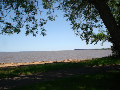
I registered 10,809 ft to the top. I think the official version is 10,847 or something like that.

It was not hard to convince me this road was closed to snow over the weekend. I found drifts on the side of the road as high as 12 ft.

The temperature dropped throughout the climb, finally stabilizing at 36F. Naturally I had my electrics going strong!

I found some sections a bit unnerving. The sun had melted snow and the runoff had refrozen in the shadows. This was my first experience riding over water laced with ice. Fortunately there were only 20 to 30 ft sections like that. Once up there, you really had little choice.


The view was unbelievable!

At one point, coming down the other side of Beartooth, I had the daylights scared out of me when a "HUGE" elk jumped up on the road beside me and began to run right beside the Wing. We exchanged wild eyed stares and I let off the throttle as quickly as I could. He cut across the road directly in front of the Wing and disappeared over the edge.

I stopped to top off my tank and take a break at The Top of the World Store, just after cresting the Beartooth.

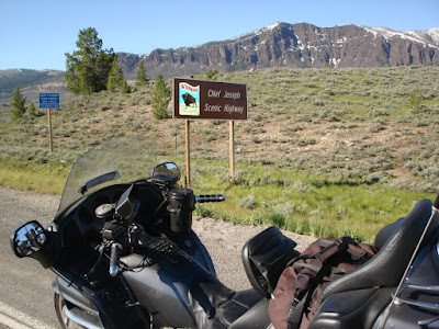
Before long I found Chief Josephs Scenic Highway and began yet another climb.

Beautiful views were everywhere you looked!


Notice the winding road climbing up the side of the mountain.


Silhouettes of indians at the top of Chief Josephs Highway.


There simply are no words to describe the views I saw today. It is an awesome ride, whether you are in a car or riding a bike. Not to be missed!

After decending Chief Josephs Hwy, I eventually rode Hwy 14 across Big Horn National Park. Entering the park from the north involves another steep climb of over 9,000 ft. Once again the temperture dropped down to the low forties and I was forced to rethink my clothing. The views in this park are beautiful as well.

After decending out of the park I eventually found my way back to I-90 and rode the interstate to Gillette, WY, where I am spending the night. The mileage today was not tremendous but the mountains I rode were worth the investment. I am tired but very happy with my day.

Tomorrow I ride the interstates with a goal of higher mileage.

To view my entire trip map page "Click Here"

To view the 24 hour SPOT map "Click Here"


Have a dream, live it. Set a goal, achieve it. ~Unknown~